Skills inventory
Cartography
An intermediate to advanced understanding of map elements and layouts, as well as projections and coordinate systems.
An intermediate to advanced understanding of map elements and layouts, as well as projections and coordinate systems.
Data collection
I collected data using a GPS device as part of my work with the Northern Virginia Regional Park Authority. One of the results of this work, a map of the Washington & Old Dominion Railroad Trail, with mileposts labeled by elevation, can be viewed here. GPS systems were also studied by me at Northern Virginia Community College as part of GIS 255 (Introduction to Remote Sensing).
I collected data using a GPS device as part of my work with the Northern Virginia Regional Park Authority. One of the results of this work, a map of the Washington & Old Dominion Railroad Trail, with mileposts labeled by elevation, can be viewed here. GPS systems were also studied by me at Northern Virginia Community College as part of GIS 255 (Introduction to Remote Sensing).
Programming
Java, C#, and Visual Basic.NET were studied at J. Sargeant Reynolds Community College; Python was self-taught and used for writing simple scripts for automating certain tasks while working with the Northern Virginia Regional Park Authority.
Java, C#, and Visual Basic.NET were studied at J. Sargeant Reynolds Community College; Python was self-taught and used for writing simple scripts for automating certain tasks while working with the Northern Virginia Regional Park Authority.
Database design
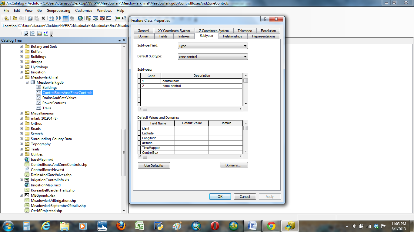
I studied SQL at J. Sargeant Reynolds Community College, and some additional understanding of databases as they relate to GIS, including domains and subtypes, was gained by me during my coursework in GIS at Northern Virginia Community College. A screenshot showing the properties of a feature class (created for the Northern Virginia Regional Park Authority's Meadowlark Botanical Gardens) showing its subtypes can be found here.
I studied SQL at J. Sargeant Reynolds Community College, and some additional understanding of databases as they relate to GIS, including domains and subtypes, was gained by me during my coursework in GIS at Northern Virginia Community College. A screenshot showing the properties of a feature class (created for the Northern Virginia Regional Park Authority's Meadowlark Botanical Gardens) showing its subtypes can be found here.
Geospatial software
ArcCatalog — used in several courses at Northern Virginia Community College and also with the Northern Virginia Regional Park Authority. The software was used for creating and managing personal and file geodatabases, importing tables from Apache OpenOffice, creating toolboxes, and building models, as well as creating and updating metadata.
ArcMap — used in several courses at Northern Virginia Community College and also with the Northern Virginia Regional Park Authority. The software (including the 3D Analyst and Spatial Analyst extensions) was used for creating maps, editing attribute tables, running queries, editing networks and topologies, digitizing vector data, and performing raster analysis.
ArcScene — used in several courses at Northern Virginia Community College. Uses included constructing lines of sight and manipulating TINs.
ArcGlobe — used in several courses at Northern Virginia Community College. Uses included watershed analysis and manipulating TINs.
DNRGPS — self-taught during my work with the Northern Virginia Regional Park Authority; used for exporting data from GPS devices to a shapefile.
Sketchup — used during coordinated internship at Northern Virginia Community College. Uses included extruding shapes and gluing components onto them. A sample of my work with Sketchup can be found here.
Web design
One of the courses at J. Sargeant Reynolds Community College (Web Page Design I (ITD 110)) gave me a basic understanding of HTML, as well as introducing me to Microsoft Visual Studio. I also wrote some code in HTML during my work with the Northern Virginia Regional Park Authority.
One of the courses at J. Sargeant Reynolds Community College (Web Page Design I (ITD 110)) gave me a basic understanding of HTML, as well as introducing me to Microsoft Visual Studio. I also wrote some code in HTML during my work with the Northern Virginia Regional Park Authority.
Remote sensing
A beginner's understanding of remote sensing was acquired in the Introduction to Remote Sensing (GIS 255) course at Northern Virginia Community College. The course saw me use Exelis VIS ENVI software for image georeferencing, change detection, and combining separate remotely-sensed imagery bands into one file.
A beginner's understanding of remote sensing was acquired in the Introduction to Remote Sensing (GIS 255) course at Northern Virginia Community College. The course saw me use Exelis VIS ENVI software for image georeferencing, change detection, and combining separate remotely-sensed imagery bands into one file.
